
Make a donation
Gear up for your next adventure:
As an Amazon Associate, this site earns from qualifying purchases at no extra cost to you.
Petite-Synthe topographic map
Click on the map to display elevation.
Make a donation
Gear up for your next adventure:
As an Amazon Associate, this site earns from qualifying purchases at no extra cost to you.
About this map
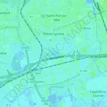
Name: Petite-Synthe topographic map, elevation, terrain.
Average elevation: 10 ft
Minimum elevation: -10 ft
Maximum elevation: 39 ft
Make a donation
Gear up for your next adventure:
As an Amazon Associate, this site earns from qualifying purchases at no extra cost to you.
Other topographic maps
Click on a map to view its topography, its elevation and its terrain.
Dunkerque
France > Hauts-de-France > Nord > Dunkerque
Le point culminant de Dunkerque est situé à 17 mètres d'altitude, il se trouve au sommet d'une butte située dans le quartier du « Grand Large ». Le paysage urbain est extrêmement plat, il est nivelé à environ 4 mètres sur l'ensemble du territoire. Ainsi le point culminant des quartiers habités de…
Average elevation: 10 ft