Geolocate

Hamirpur topographic map

Click on the map to display elevation.

About this map

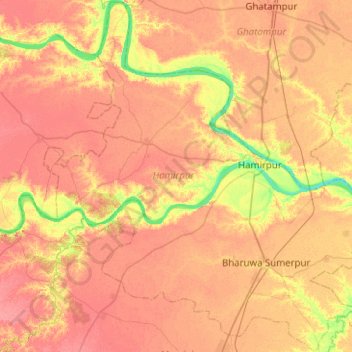
Name: Hamirpur topographic map, elevation, terrain.

Location: Hamirpur, Hamirpur District, Uttar Pradesh, India (25.71231 79.84250 26.16045 80.34464)

Average elevation: 397 ft

Minimum elevation: 285 ft

Maximum elevation: 459 ft

Gear up for your next adventure:

📡GPS Antenna Upgrade - Enhance GPS reception in remote terrain
🧤Hiking Gloves - Protective gloves for rugged trails
🪶Fire Starter Kit - Reliable fire starter for survival and camping
🧼Biodegradable Camping Soap - Eco‑friendly soap for outdoor hygiene
🛌Ultralight Sleeping Bags - Compact down bags for cold nights in the wilderness

As an Amazon Associate, this site earns from qualifying purchases at no extra cost to you.