
Thank you for supporting this site ❤️
Make a donation
Make a donation
Gear up for your next adventure:
As an Amazon Associate, this site earns from qualifying purchases at no extra cost to you.
Queirela topographic map
Click on the map to display elevation.
Thank you for supporting this site ❤️
Make a donation
Make a donation
Gear up for your next adventure:
As an Amazon Associate, this site earns from qualifying purchases at no extra cost to you.
About this map
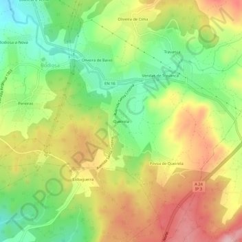
Name: Queirela topographic map, elevation, terrain.
Location: Queirela, Bodiosa, Viseu, 3515-619, Portugal (40.68820 -7.99548 40.72820 -7.95548)
Average elevation: 1,637 ft
Minimum elevation: 1,332 ft
Maximum elevation: 1,975 ft
Thank you for supporting this site ❤️
Make a donation
Make a donation
Gear up for your next adventure:
As an Amazon Associate, this site earns from qualifying purchases at no extra cost to you.