
Bezirk Unterklettgau topographic map
Interactive map
Click on the map to display elevation.
About this map
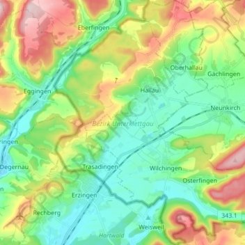
Name: Bezirk Unterklettgau topographic map, elevation, terrain.
Location: Bezirk Unterklettgau, Schaffhouse, Suisse (47.63842 8.40465 47.73013 8.53466)
Average elevation: 1,598 ft
Minimum elevation: 1,276 ft
Maximum elevation: 2,241 ft
Other topographic maps
Click on a map to view its topography, its elevation and its terrain.
Neuhausen am Rheinfall
Neuhausen am Rheinfall, Schaffhouse, 8212, Suisse
Average elevation: 1,476 ft
Stein am Rhein
Stein am Rhein, Schaffhouse, 8260, Suisse
Average elevation: 1,555 ft
Neunkirch
Suisse > Schaffhouse > Bezirk Oberklettgau
Neunkirch, Bezirk Oberklettgau, Schaffhouse, 8213, Suisse
Average elevation: 1,598 ft
Bezirk Oberklettgau
Bezirk Oberklettgau, Schaffhouse, Suisse
Average elevation: 1,785 ft
Trasadingen
Suisse > Schaffhouse > Bezirk Unterklettgau
Trasadingen, Bezirk Unterklettgau, Schaffhouse, 8219, Suisse
Average elevation: 1,457 ft