
Make a donation
Gear up for your next adventure:
As an Amazon Associate, this site earns from qualifying purchases at no extra cost to you.
Secunda topographic map
Click on the map to display elevation.
Make a donation
Gear up for your next adventure:
As an Amazon Associate, this site earns from qualifying purchases at no extra cost to you.
About this map
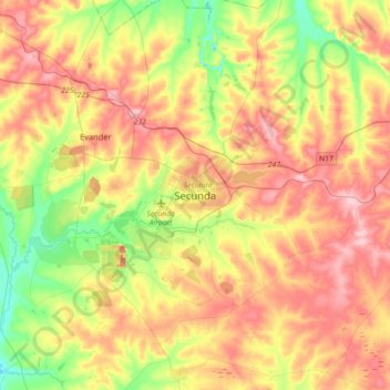
Name: Secunda topographic map, elevation, terrain.
Average elevation: 5,312 ft
Minimum elevation: 5,066 ft
Maximum elevation: 5,558 ft
Make a donation
Gear up for your next adventure:
As an Amazon Associate, this site earns from qualifying purchases at no extra cost to you.
Other topographic maps
Click on a map to view its topography, its elevation and its terrain.
Grootdraai Dam
South Africa > Mpumalanga > Gert Sibande > Lekwa Local Municipality
Average elevation: 5,082 ft
Vygeboom Dam
South Africa > Mpumalanga > Gert Sibande > Albert Luthuli Local Municipality
Average elevation: 3,465 ft
Make a donation
Gear up for your next adventure:
As an Amazon Associate, this site earns from qualifying purchases at no extra cost to you.
Heyshope Dam
South Africa > Mpumalanga > Gert Sibande > Mkhondo Local Municipality
Average elevation: 4,347 ft
Dipaleseng Ward 2
South Africa > Mpumalanga > Gert Sibande > Dipaleseng Local Municipality
Average elevation: 5,371 ft
Make a donation
Gear up for your next adventure:
As an Amazon Associate, this site earns from qualifying purchases at no extra cost to you.
Albert Luthuli Local Municipality
South Africa > Mpumalanga > Gert Sibande
Average elevation: 4,931 ft
Pixley Ka Seme Local Municipality
South Africa > Mpumalanga > Gert Sibande
Average elevation: 5,374 ft
Mpuluzi
South Africa > Mpumalanga > Gert Sibande > Albert Luthuli Local Municipality
Average elevation: 5,308 ft
Make a donation
Gear up for your next adventure:
As an Amazon Associate, this site earns from qualifying purchases at no extra cost to you.
Mkhondo Ward 4
South Africa > Mpumalanga > Gert Sibande > Mkhondo Local Municipality
Average elevation: 4,633 ft
Make a donation
Gear up for your next adventure:
As an Amazon Associate, this site earns from qualifying purchases at no extra cost to you.
Mpuluzi
South Africa > Mpumalanga > Gert Sibande > Albert Luthuli Local Municipality
Average elevation: 4,783 ft
Albert Luthuli Local Municipality
South Africa > Mpumalanga > Gert Sibande
Average elevation: 4,931 ft
Mpuluzi
South Africa > Mpumalanga > Gert Sibande > Albert Luthuli Local Municipality
Average elevation: 4,783 ft
Heyshope Dam
South Africa > Mpumalanga > Gert Sibande > Mkhondo Local Municipality
Average elevation: 4,347 ft
Make a donation
Gear up for your next adventure:
As an Amazon Associate, this site earns from qualifying purchases at no extra cost to you.
Albert Luthuli Local Municipality
South Africa > Mpumalanga > Gert Sibande
Average elevation: 4,931 ft
Make a donation
Gear up for your next adventure:
As an Amazon Associate, this site earns from qualifying purchases at no extra cost to you.
Make a donation
Gear up for your next adventure:
As an Amazon Associate, this site earns from qualifying purchases at no extra cost to you.
Grootdraai Dam
South Africa > Mpumalanga > Gert Sibande > Lekwa Local Municipality
Average elevation: 5,082 ft
Pixley Ka Seme Local Municipality
South Africa > Mpumalanga > Gert Sibande
Average elevation: 5,374 ft
Blesbokspruit
South Africa > Mpumalanga > Gert Sibande > Lekwa Local Municipality
Average elevation: 5,269 ft
Make a donation
Gear up for your next adventure:
As an Amazon Associate, this site earns from qualifying purchases at no extra cost to you.