Geolocate

Cataract topographic map

Click on the map to display elevation.

About this map

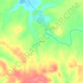
Name: Cataract topographic map, elevation, terrain.

Location: Cataract, Owen County, Indiana, United States (39.40755 -86.83640 39.44755 -86.79640)

Average elevation: 784 ft

Minimum elevation: 636 ft

Maximum elevation: 935 ft

Owen County trails, hiking, mountain biking, running and outdoor activities

Other topographic maps

Click on a map to view its topography, its elevation and its terrain.

Gosport

United States > Indiana > Owen County

Average elevation: 604 ft

Spencer

United States > Indiana > Owen County

Average elevation: 584 ft

Gear up for your next adventure:

🧢Sun Protection Hats - Wide-brimmed and UPF-rated hats for high-altitude sun safety
🏔️Mountain Trail Maps - High‑detail maps for popular peaks
🛶Inflatable Kayak - Portable kayak for rivers, lakes, and expeditions
🔌USB Car Charger - Car charger for on‑the‑go power needs
📱Heavy-Duty Phone Cases - Drop-proof and waterproof protection for outdoor navigation

As an Amazon Associate, this site earns from qualifying purchases at no extra cost to you.