Geolocate

Oshkosh topographic map

Click on the map to display elevation.

About this map

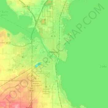
Name: Oshkosh topographic map, elevation, terrain.

Location: Oshkosh, Winnebago County, Wisconsin, United States (43.94504 -88.62270 44.09057 -88.50787)

Average elevation: 771 ft

Minimum elevation: 666 ft

Maximum elevation: 935 ft

Winnebago County trails, hiking, mountain biking, running and outdoor activities

Other topographic maps

Click on a map to view its topography, its elevation and its terrain.

Piacenza

United States > Wisconsin > Winnebago County > Piacenza

Average elevation: 758 ft

Gear up for your next adventure:

🛠️Backpacking Tool Kit - Essential toolkit for outdoor repairs
🏫Relief Map Kits - Hands-on tools for teaching landforms and elevation
🛰️Satellite Messengers - Emergency SOS and two-way messaging for off-grid adventures
🏔️Mountain Trail Maps - High‑detail maps for popular peaks
🧢Outdoor Hiking Hat - Sun protection hat for outdoor explorers

As an Amazon Associate, this site earns from qualifying purchases at no extra cost to you.