Geolocate

Guantanamo topographic map

Click on the map to display elevation.

About this map

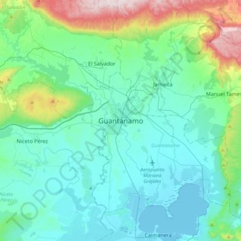
Name: Guantanamo topographic map, elevation, terrain.

Location: Guantanamo, Guantánamo, 95100, Cuba (19.98318 -75.36348 20.30318 -75.04348)

Average elevation: 482 ft

Minimum elevation: -10 ft

Maximum elevation: 2,661 ft

Gear up for your next adventure:

🔭Stargazing Telescopes - Perfect for camping in low-light pollution areas shown on maps
🔌USB Car Charger - Car charger for on‑the‑go power needs
🥾Women's Hiking Boots - Top-rated trail boots with ankle support and superior grip
🧯Portable Fire Pit - Compact fire pit for camping spots
🛡️Bear Spray Outdoor - Protection in bear country hikes

As an Amazon Associate, this site earns from qualifying purchases at no extra cost to you.