
Thank you for supporting this site ❤️
Make a donation
Make a donation
Gear up for your next adventure:
As an Amazon Associate, this site earns from qualifying purchases at no extra cost to you.
Chotrana topographic map
Click on the map to display elevation.
Thank you for supporting this site ❤️
Make a donation
Make a donation
Gear up for your next adventure:
As an Amazon Associate, this site earns from qualifying purchases at no extra cost to you.
About this map
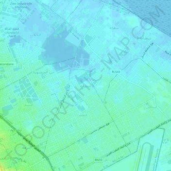
Name: Chotrana topographic map, elevation, terrain.
Location: Chotrana, التعمير, معتمدية سكرة, Ariana, 2073, Tunisia (36.86120 10.19182 36.90120 10.23182)
Average elevation: 13 ft
Minimum elevation: -30 ft
Maximum elevation: 59 ft
Thank you for supporting this site ❤️
Make a donation
Make a donation
Gear up for your next adventure:
As an Amazon Associate, this site earns from qualifying purchases at no extra cost to you.