Geolocate

Cobh topographic map

Click on the map to display elevation.

About this map

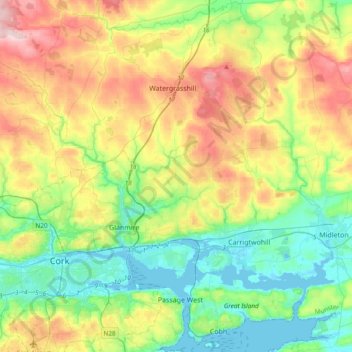
Name: Cobh topographic map, elevation, terrain.

Location: Cobh, County Cork, Munster, Ireland (51.84282 -8.61626 52.09415 -8.18838)

Average elevation: 322 ft

Minimum elevation: -7 ft

Maximum elevation: 1,348 ft

Gear up for your next adventure:

🔪Outdoor Multitools - Essential survival tools for gear repair and field use
🌐World Map Poster - Decorative world maps with topographic info
🚁Photography Drones - Capture stunning aerial views of landforms and topography
🛏️Cold Weather Sleeping Bag - Warm sleeping bag for cold conditions
🌄Hiking Binoculars - Compact binoculars for scenic views and trail spotting

As an Amazon Associate, this site earns from qualifying purchases at no extra cost to you.