
Make a donation
Gear up for your next adventure:
As an Amazon Associate, this site earns from qualifying purchases at no extra cost to you.
Lào Cai topographic map
Click on the map to display elevation.
Make a donation
Gear up for your next adventure:
As an Amazon Associate, this site earns from qualifying purchases at no extra cost to you.
About this map
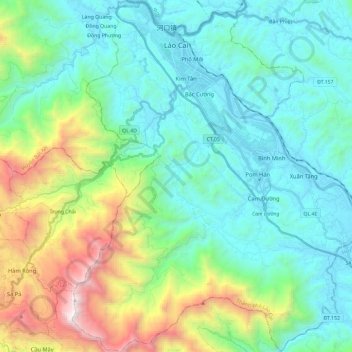
Name: Lào Cai topographic map, elevation, terrain.
Location: Lào Cai, Lao Cai province, Vietnam (22.31002 103.89662 22.52635 104.06324)
Average elevation: 1,575 ft
Minimum elevation: 207 ft
Maximum elevation: 7,743 ft
Make a donation
Gear up for your next adventure:
As an Amazon Associate, this site earns from qualifying purchases at no extra cost to you.
Other topographic maps
Click on a map to view its topography, its elevation and its terrain.
Fansipan Mountain
Vietnam > Lao Cai province > Tân Uyên District > Sa Pa > Xã Hoàng Liên
Fansipan is the tallest mountain in the Hoang Lien Son range, situated on the border of Lào Cai and Lai Châu provinces, with its peak located on the Lào Cai side. The mountain is part of Hoàng Liên National Park. It has a topographic prominence of 1,617 metres (5,305 ft), ranking sixth in Vietnam.
Average elevation: 8,583 ft
Make a donation
Gear up for your next adventure:
As an Amazon Associate, this site earns from qualifying purchases at no extra cost to you.