Geolocate

Imus topographic map

Click on the map to display elevation.

About this map

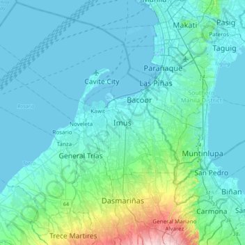
Name: Imus topographic map, elevation, terrain.

Location: Imus, Cavite, Calabarzon, 4103, Philippines (14.25932 120.77126 14.57932 121.09126)

Average elevation: 102 ft

Minimum elevation: -10 ft

Maximum elevation: 797 ft

Other topographic maps

Click on a map to view its topography, its elevation and its terrain.

Anabu II-C

Philippines > Cavite > Imus

Average elevation: 108 ft

Alapan II-B

Philippines > Cavite > Imus

Average elevation: 66 ft

Alapan II-A

Philippines > Cavite > Imus

Average elevation: 39 ft

Poblacion IV-A

Philippines > Cavite > Imus

Average elevation: 33 ft

Gear up for your next adventure:

🏫Relief Map Kits - Hands-on tools for teaching landforms and elevation
📱Solar Portable Charger - Solar power bank for charging devices off‑grid
🔪Outdoor Multitools - Essential survival tools for gear repair and field use
👟Men's Trail Runners - Lightweight footwear for fast-paced exploration and light hiking
🛰️Satellite Messengers - Emergency SOS and two-way messaging for off-grid adventures

As an Amazon Associate, this site earns from qualifying purchases at no extra cost to you.