
Thank you for supporting this site ❤️
Make a donation
Make a donation
Gear up for your next adventure:
As an Amazon Associate, this site earns from qualifying purchases at no extra cost to you.
Zabrzeż topographic map
Click on the map to display elevation.
Thank you for supporting this site ❤️
Make a donation
Make a donation
Gear up for your next adventure:
As an Amazon Associate, this site earns from qualifying purchases at no extra cost to you.
About this map
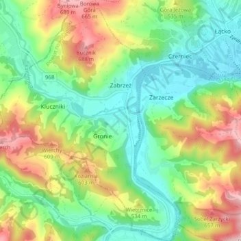
Name: Zabrzeż topographic map, elevation, terrain.
Average elevation: 1,572 ft
Minimum elevation: 1,148 ft
Maximum elevation: 2,316 ft
Thank you for supporting this site ❤️
Make a donation
Make a donation
Gear up for your next adventure:
As an Amazon Associate, this site earns from qualifying purchases at no extra cost to you.
Other topographic maps
Click on a map to view its topography, its elevation and its terrain.
Święty Krzyż
Poland > Lesser Poland Voivodeship > Nowy Sącz County > Królowa Polska > Góry
Average elevation: 1,519 ft