
Tazrout topographic map
Interactive map
Click on the map to display elevation.
About this map
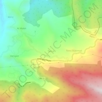
Name: Tazrout topographic map, elevation, terrain.
Location: Tazrout, Adekar, Daïra d'Adekar, Béjaïa, 06021, Algérie (36.70391 4.57615 36.74391 4.61615)
Average elevation: 2,805 ft
Minimum elevation: 1,476 ft
Maximum elevation: 4,593 ft
Other topographic maps
Click on a map to view its topography, its elevation and its terrain.
Lac noir
Algérie > Béjaïa > Daïra d'Adekar > Adekar
Lac noir, Adekar, Daïra d'Adekar, Béjaïa, 06021, Algérie
Average elevation: 4,124 ft