
Lac noir topographic map
Interactive map
Click on the map to display elevation.
About this map
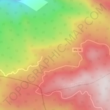
Name: Lac noir topographic map, elevation, terrain.
Location: Lac noir, Adekar, Daïra d'Adekar, Béjaïa, 06021, Algérie (36.69567 4.60153 36.69720 4.60363)
Average elevation: 4,124 ft
Minimum elevation: 2,799 ft
Maximum elevation: 4,977 ft
Other topographic maps
Click on a map to view its topography, its elevation and its terrain.
Tazrout
Algérie > Béjaïa > Daïra d'Adekar > Adekar
Tazrout, Adekar, Daïra d'Adekar, Béjaïa, 06021, Algérie
Average elevation: 2,805 ft