Geolocate

Herington topographic map

Click on the map to display elevation.

About this map

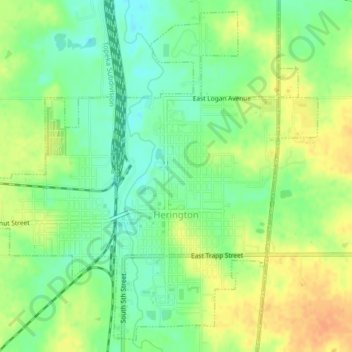
Name: Herington topographic map, elevation, terrain.

Location: Herington, Dickinson County, Kansas, United States (38.65952 -96.96722 38.68979 -96.92572)

Average elevation: 1,362 ft

Minimum elevation: 1,302 ft

Maximum elevation: 1,424 ft

Dickinson County trails, hiking, mountain biking, running and outdoor activities

Other topographic maps

Click on a map to view its topography, its elevation and its terrain.

Industry

United States > Kansas > Dickinson County

Average elevation: 1,214 ft

Gear up for your next adventure:

📱Solar Portable Charger - Solar power bank for charging devices off‑grid
🪶Fire Starter Kit - Reliable fire starter for survival and camping
🧭Map Reading Tools - Tools and kits for map navigation
🦺Reflective Outdoor Gear - Safety gear for low‑light conditions
🧢Outdoor Hiking Hat - Sun protection hat for outdoor explorers

As an Amazon Associate, this site earns from qualifying purchases at no extra cost to you.