
Make a donation
Gear up for your next adventure:
As an Amazon Associate, this site earns from qualifying purchases at no extra cost to you.
Mem Martins topographic map
Click on the map to display elevation.
Make a donation
Gear up for your next adventure:
As an Amazon Associate, this site earns from qualifying purchases at no extra cost to you.
About this map
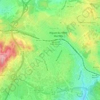
Name: Mem Martins topographic map, elevation, terrain.
Location: Mem Martins, Sintra, Lisboa, 2725-328, Portugal (38.77358 -9.36399 38.81358 -9.32399)
Average elevation: 607 ft
Minimum elevation: 364 ft
Maximum elevation: 958 ft
Make a donation
Gear up for your next adventure:
As an Amazon Associate, this site earns from qualifying purchases at no extra cost to you.
Other topographic maps
Click on a map to view its topography, its elevation and its terrain.
Make a donation
Gear up for your next adventure:
As an Amazon Associate, this site earns from qualifying purchases at no extra cost to you.
Palácio Nacional da Pena
A planta do edifício é bastante irregular e está condicionada por uma construção ali preexistente – a Capela de Nossa Senhora da Pena – e ainda pela topografia. O resultado é um núcleo sensivelmente quadrangular, organizado à volta de claustro e um outro alongado.
Average elevation: 997 ft
Make a donation
Gear up for your next adventure:
As an Amazon Associate, this site earns from qualifying purchases at no extra cost to you.