
Indian Heaven Wilderness topographic map
Interactive map
Click on the map to display elevation.
About this map
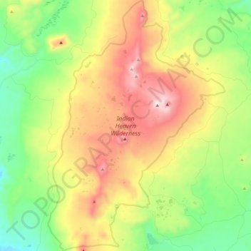
Name: Indian Heaven Wilderness topographic map, elevation, terrain.
Average elevation: 3,907 ft
Minimum elevation: 2,595 ft
Maximum elevation: 5,801 ft
Lava once flowed from the numerous volcanic cones that rise above the plateau, consisting mainly of overlapping shield volcanoes, spatter cones, and cinder cones, which averages 4,500 feet (1,400 m) in elevation. The wilderness' highest point is Lemei Rock (5,927 ft), whose crater now contains Lake Wapiki. Other prominent volcanic peaks include Bird Mountain, Sawtooth Mountain, Gifford Peak, East Crater, and Red Mountain. Big Lava Bed is the result of the most recent volcanic activity about 8,200 years ago.
Other topographic maps
Click on a map to view its topography, its elevation and its terrain.
Mount Saint Helens
United States > Washington > Skamania County
Mount Saint Helens, Skamania County, Washington, United States
Average elevation: 6,877 ft
Camp Kwoneesum Dam
United States > Washington > Skamania County
Camp Kwoneesum Dam, Skamania County, Washington, United States
Average elevation: 1,125 ft
Northwoods
United States > Washington > Skamania County
Northwoods, Skamania County, Washington, United States
Average elevation: 1,467 ft
Underwood
United States > Washington > Skamania County
Underwood, Skamania County, Washington, 98605, United States
Average elevation: 381 ft
Sleeping Beauty
United States > Washington > Skamania County
Sleeping Beauty, Skamania County, Washington, United States
Average elevation: 3,868 ft
Lake Bonneville
United States > Washington > Skamania County
Lake Bonneville, Skamania County, Washington, 98639, United States
Average elevation: 269 ft
Spirit Lake
United States > Washington > Skamania County
Spirit Lake, Skamania County, Washington, United States
Average elevation: 3,753 ft
Lava Dome
United States > Washington > Skamania County
Lava Dome, Skamania County, Washington, United States
Average elevation: 6,919 ft
Skamania
United States > Washington > Skamania County
Skamania, Skamania County, Washington, 97014, United States
Average elevation: 194 ft
North Bonneville
United States > Washington > Skamania County > North Bonneville
North Bonneville, Skamania County, Washington, 98639, United States
Average elevation: 659 ft
Stevenson
United States > Washington > Skamania County
Stevenson, Skamania County, Washington, 98648, United States
Average elevation: 246 ft
Carson
United States > Washington > Skamania County > Carson
Carson, Skamania County, Washington, 98610, United States
Average elevation: 751 ft
Sunset Falls
United States > Washington > Skamania County
Sunset Falls, Skamania County, Washington, United States
Average elevation: 1,499 ft
Beacon Rock
United States > Washington > Skamania County
Beacon Rock, Skamania County, Washington, 97014, United States
Average elevation: 305 ft
Mount Saint Helens National Volcanic Monument
United States > Washington > Skamania County
Mount Saint Helens National Volcanic Monument, Skamania County, Washington, United States
Average elevation: 2,940 ft