
Northwoods topographic map
Click on the map to display elevation.
About this map
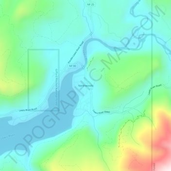
Name: Northwoods topographic map, elevation, terrain.
Location: Northwoods, Skamania County, Washington, United States (46.04090 -122.03947 46.08090 -121.99947)
Average elevation: 1,467 ft
Minimum elevation: 965 ft
Maximum elevation: 3,153 ft
Skamania County trails, hiking, mountain biking, running and outdoor activities
Other topographic maps
Click on a map to view its topography, its elevation and its terrain.
North Bonneville
United States > Washington > Skamania County > North Bonneville
Average elevation: 659 ft
Spirit Lake
United States > Washington > Skamania County
Prior to 1980, Spirit Lake consisted of two arms that occupied what had been the valleys of the North Fork Toutle River and a tributary. About 4,000 years ago, these valleys were blocked by lahars and pyroclastic flow deposits from Mount St. Helens to form the pre-1980 Spirit Lake. The longest branch of Spirit…
Average elevation: 3,753 ft
Indian Heaven Wilderness
United States > Washington > Skamania County
Lava once flowed from the numerous volcanic cones that rise above the plateau, consisting mainly of overlapping shield volcanoes, spatter cones, and cinder cones, which averages 4,500 feet (1,400 m) in elevation. The wilderness' highest point is Lemei Rock (5,927 ft), whose crater now contains Lake Wapiki.…
Average elevation: 3,907 ft