Geolocate

Molfetta topographic map

Click on the map to display elevation.

About this map

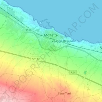
Name: Molfetta topographic map, elevation, terrain.

Location: Molfetta, Bari, Apulia, 70056, Italy (41.13813 16.50863 41.22948 16.64025)

Average elevation: 177 ft

Minimum elevation: -3 ft

Maximum elevation: 607 ft

Other topographic maps

Click on a map to view its topography, its elevation and its terrain.

Altamura

Italy > Apulia > Bari > Altamura

Average elevation: 1,342 ft

Polignano a Mare

Italy > Apulia > Bari

Average elevation: 138 ft

Monte Belvedere

Italy > Apulia > Bari > Altamura

Average elevation: 1,496 ft

Gear up for your next adventure:

🏔️Mountain Trail Maps - High‑detail maps for popular peaks
🍳Camping Cook Set - Complete cookware for outdoor meals
🔥Fast-Boil Camping Stoves - Efficient cooking systems for quick trail meals
🪄Magnetic Compass - Accurate compass for navigation
🛰️Satellite Messengers - Emergency SOS and two-way messaging for off-grid adventures

As an Amazon Associate, this site earns from qualifying purchases at no extra cost to you.