
Make a donation
Gear up for your next adventure:
As an Amazon Associate, this site earns from qualifying purchases at no extra cost to you.
Kleineichen topographic map
Click on the map to display elevation.
Make a donation
Gear up for your next adventure:
As an Amazon Associate, this site earns from qualifying purchases at no extra cost to you.
About this map
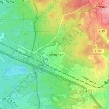
Name: Kleineichen topographic map, elevation, terrain.
Average elevation: 312 ft
Minimum elevation: 167 ft
Maximum elevation: 548 ft
Make a donation
Gear up for your next adventure:
As an Amazon Associate, this site earns from qualifying purchases at no extra cost to you.
Other topographic maps
Click on a map to view its topography, its elevation and its terrain.
Wahner Heide
Deutschland > Nordrhein-Westfalen > Rheinisch-Bergischer Kreis > Rösrath > Rambrücken
Geologisch-naturräumlich stellt die Wahner Heide den südlichen Teil der Bergischen Heideterrasse dar, einer rechtsrheinischen Mittelterrassenebene, die sich in einer 8 bis 10 Meter hohen Höhenstufe von der westlich angrenzenden Niederterrasse abhebt. Zu den im Osten deutlich ansteigenden Bergischen…
Average elevation: 285 ft