Geolocate

Barney topographic map

Click on the map to display elevation.

About this map

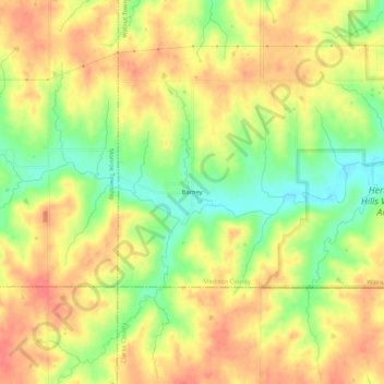
Name: Barney topographic map, elevation, terrain.

Location: Barney, Walnut Township, Madison County, Iowa, United States (41.14666 -94.02384 41.18666 -93.98384)

Average elevation: 1,135 ft

Minimum elevation: 1,020 ft

Maximum elevation: 1,217 ft

Madison County trails, hiking, mountain biking, running and outdoor activities

Other topographic maps

Click on a map to view its topography, its elevation and its terrain.

Earlham

United States > Iowa > Madison County

Average elevation: 1,086 ft

Earlham

United States > Iowa > Madison County

Average elevation: 1,086 ft

East Peru

United States > Iowa > Madison County

Average elevation: 1,007 ft

Patterson

United States > Iowa > Madison County

Average elevation: 928 ft

Winterset

United States > Iowa > Madison County

Average elevation: 1,102 ft

Saint Charles

United States > Iowa > Madison County

Average elevation: 1,037 ft

Truro

United States > Iowa > Madison County

Average elevation: 1,056 ft

Gear up for your next adventure:

🛰️Satellite Messengers - Emergency SOS and two-way messaging for off-grid adventures
Camping Coffee Makers - Enjoy premium coffee at the summit or campsite
🪶Camping Sleeping Pad - Comfortable sleeping pad for backpacking
🛡️Insect Repellent - Protection against bugs during outdoor activities
📱Solar Portable Charger - Solar power bank for charging devices off‑grid

As an Amazon Associate, this site earns from qualifying purchases at no extra cost to you.