
Herdade topographic map
Interactive map
Click on the map to display elevation.
About this map
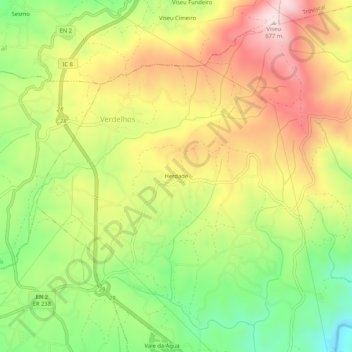
Name: Herdade topographic map, elevation, terrain.
Location: Herdade, Sertã, Castelo Branco, 6100-679, Portugal (39.83457 -8.13227 39.87457 -8.09227)
Average elevation: 1,509 ft
Minimum elevation: 846 ft
Maximum elevation: 2,198 ft
Other topographic maps
Click on a map to view its topography, its elevation and its terrain.
Cernache do Bonjardim, Nesperal e Palhais
Portugal > Castelo Branco > Sertã
Cernache do Bonjardim, Nesperal e Palhais, Sertã, Castelo Branco, Portugal
Average elevation: 866 ft
Amioso
Portugal > Castelo Branco > Sertã
Amioso, Sertã, Castelo Branco, 6100-679, Portugal
Average elevation: 1,568 ft