Geolocate

Cascada topographic map

Click on the map to display elevation.

About this map

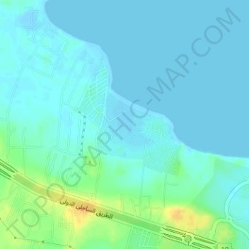
Name: Cascada topographic map, elevation, terrain.

Location: Cascada, Matruh, Egypt (30.98492 28.71532 30.99237 28.72186)

Average elevation: 20 ft

Minimum elevation: -7 ft

Maximum elevation: 92 ft

Other topographic maps

Click on a map to view its topography, its elevation and its terrain.

Fort Shally top view

Egypt > Matruh > Siwa Oasis

Average elevation: -39 ft

Ras Alem Ghomed

Egypt > Matruh

Average elevation: 33 ft

Al Daba‘ a

Egypt > Matruh

Average elevation: 95 ft

Gear up for your next adventure:

🔊Portable Camp Speaker - Music and alerts at camp
🔌Solar Panel Charger - Charge gear sustainably outdoors
🦶Hiking Gaiters - Keep debris and water out of your boots
🔥Camping Stove - Portable stove for camping and backcountry cooking
🎒Trail Energy Bars - High‑calorie bars for hiking energy

As an Amazon Associate, this site earns from qualifying purchases at no extra cost to you.