
Moos topographic map
Click on the map to display elevation.
About this map
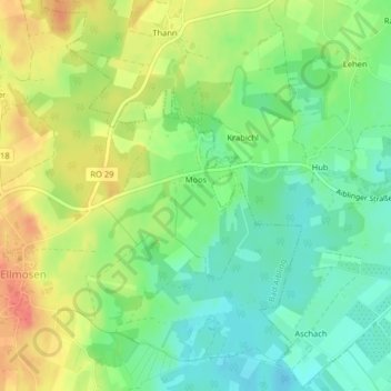
Name: Moos topographic map, elevation, terrain.
Average elevation: 1,585 ft
Minimum elevation: 1,506 ft
Maximum elevation: 1,683 ft
Other topographic maps
Click on a map to view its topography, its elevation and its terrain.
Zell
Deutschland > Bayern > Landkreis Rosenheim > Bad Aibling > Ellmosen > Zell
Average elevation: 1,585 ft