
Make a donation
Gear up for your next adventure:
As an Amazon Associate, this site earns from qualifying purchases at no extra cost to you.
Curwensville topographic map
Click on the map to display elevation.
Make a donation
Gear up for your next adventure:
As an Amazon Associate, this site earns from qualifying purchases at no extra cost to you.
About this map
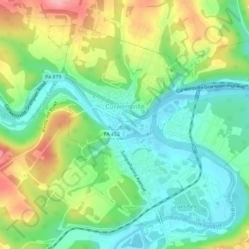
Name: Curwensville topographic map, elevation, terrain.
Location: Curwensville, Clearfield County, Pennsylvania, United States (40.96026 -78.53995 40.98617 -78.49765)
Average elevation: 1,296 ft
Minimum elevation: 1,119 ft
Maximum elevation: 1,608 ft
Clearfield County trails, hiking, mountain biking, running and outdoor activities
Make a donation
Gear up for your next adventure:
As an Amazon Associate, this site earns from qualifying purchases at no extra cost to you.
Other topographic maps
Click on a map to view its topography, its elevation and its terrain.
Barrett
United States > Pennsylvania > Clearfield County > Bradford Township
Average elevation: 1,352 ft
Grassflat
United States > Pennsylvania > Clearfield County > Cooper Township
Average elevation: 1,572 ft
Make a donation
Gear up for your next adventure:
As an Amazon Associate, this site earns from qualifying purchases at no extra cost to you.
Bigler
United States > Pennsylvania > Clearfield County > Bradford Township
Average elevation: 1,729 ft
Hawk Run
United States > Pennsylvania > Clearfield County > Morris Township
Average elevation: 1,493 ft
Oklahoma
United States > Pennsylvania > Clearfield County > Sandy Township
Average elevation: 1,470 ft
Make a donation
Gear up for your next adventure:
As an Amazon Associate, this site earns from qualifying purchases at no extra cost to you.
West Decatur
United States > Pennsylvania > Clearfield County > Boggs Township
Average elevation: 1,670 ft
Beccaria
United States > Pennsylvania > Clearfield County > Beccaria Township
Average elevation: 1,532 ft
Karthaus
United States > Pennsylvania > Clearfield County > Karthaus Township
Average elevation: 1,171 ft
Lecontes Mills
United States > Pennsylvania > Clearfield County > Girard Township
Average elevation: 1,391 ft
Make a donation
Gear up for your next adventure:
As an Amazon Associate, this site earns from qualifying purchases at no extra cost to you.
Luthersburg
United States > Pennsylvania > Clearfield County > Brady Township
Average elevation: 1,765 ft
New Millport
United States > Pennsylvania > Clearfield County > Knox Township
Average elevation: 1,549 ft
Make a donation
Gear up for your next adventure:
As an Amazon Associate, this site earns from qualifying purchases at no extra cost to you.
Pottersdale
United States > Pennsylvania > Clearfield County > Karthaus Township
Average elevation: 1,293 ft
Smoke Run
United States > Pennsylvania > Clearfield County > Bigler Township
Average elevation: 1,496 ft
Make a donation
Gear up for your next adventure:
As an Amazon Associate, this site earns from qualifying purchases at no extra cost to you.
Winburne
United States > Pennsylvania > Clearfield County > Cooper Township
Average elevation: 1,519 ft
Woodland
United States > Pennsylvania > Clearfield County > Bradford Township
Average elevation: 1,657 ft
Utahville
United States > Pennsylvania > Clearfield County > Beccaria Township > Utahville
Average elevation: 1,650 ft
Anderson
United States > Pennsylvania > Clearfield County > Union Township > Anderson
Average elevation: 1,811 ft
Make a donation
Gear up for your next adventure:
As an Amazon Associate, this site earns from qualifying purchases at no extra cost to you.
Parsonsville
United States > Pennsylvania > Clearfield County > Decatur Township
Average elevation: 1,627 ft
Home Camp
United States > Pennsylvania > Clearfield County > Union Township
Average elevation: 1,762 ft