Geolocate

Heilbron topographic map

Click on the map to display elevation.

About this map

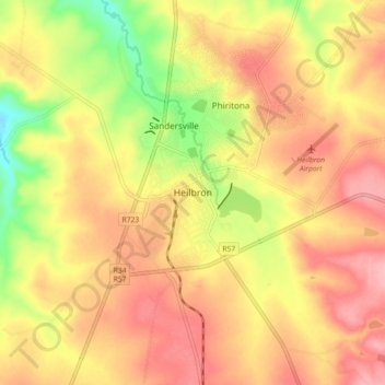
Name: Heilbron topographic map, elevation, terrain.

Location: Heilbron, Ngwathe Local Municipality, Fezile Dabi District Municipality, Free State, 9650, South Africa (-27.32639 27.92944 -27.24639 28.00944)

Average elevation: 5,115 ft

Minimum elevation: 4,879 ft

Maximum elevation: 5,272 ft

Other topographic maps

Click on a map to view its topography, its elevation and its terrain.

Gear up for your next adventure:

🔊Portable Camp Speaker - Music and alerts at camp
🪶Trail Camera - Capture wildlife on your hikes
Backpacking Tents - Weight-optimized shelters for multi-day topographic surveys
🗃️Trail First Aid Kit - Essential kit for outdoor injuries and emergencies
Backpacking Tent - Lightweight and durable tent for multi‑day hikes

As an Amazon Associate, this site earns from qualifying purchases at no extra cost to you.