Geolocate

Rock Spring topographic map

Click on the map to display elevation.

About this map

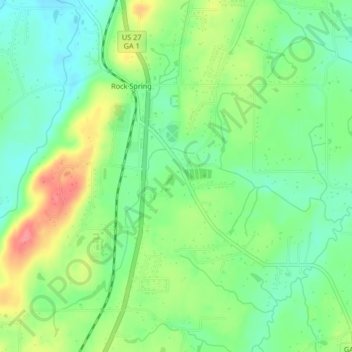
Name: Rock Spring topographic map, elevation, terrain.

Location: Rock Spring, Walker County, Georgia, 30739, United States (34.79916 -85.25599 34.83180 -85.21454)

Average elevation: 863 ft

Minimum elevation: 755 ft

Maximum elevation: 1,040 ft

Walker County trails, hiking, mountain biking, running and outdoor activities

Other topographic maps

Click on a map to view its topography, its elevation and its terrain.

Flintstone

United States > Georgia > Walker County

Average elevation: 846 ft

Marsh Crossing

United States > Georgia > Walker County

Average elevation: 1,024 ft

Rock Spring

United States > Georgia > Walker County

Average elevation: 853 ft

Cenchat

United States > Georgia > Walker County

Average elevation: 843 ft

Yates Lake

United States > Georgia > Walker County

Average elevation: 1,168 ft

Walnut Grove

United States > Georgia > Walker County

Average elevation: 823 ft

Missionary Ridge

United States > Georgia > Walker County

Average elevation: 1,106 ft

White Oak

United States > Georgia > Walker County > White Oak

Average elevation: 817 ft

Gear up for your next adventure:

🔊Portable Camp Speaker - Music and alerts at camp
🪶Multi‑Purpose Knife - Useful blade for camp and trail
👟Trail Running Shoes - Lightweight shoes for trail runners
🪶Compact Camp Shovel - Folding shovel for campsite tasks
⛑️Personal Locator Beacon - Safety beacon for emergencies

As an Amazon Associate, this site earns from qualifying purchases at no extra cost to you.