
Make a donation
Gear up for your next adventure:
As an Amazon Associate, this site earns from qualifying purchases at no extra cost to you.
Beernem topographic map
Click on the map to display elevation.
Make a donation
Gear up for your next adventure:
As an Amazon Associate, this site earns from qualifying purchases at no extra cost to you.
Beernem
Beernem ligt in Zandig Vlaanderen op een hoogte van ongeveer 11 meter. Het Kanaal Gent-Brugge ligt ten zuiden van de dorpskom. Men vindt ten zuiden van dit kanaal nog een wijk: Heilige Maria, Moeder Gods, en daar ligt ook het psychiatrisch ziekenhuis en het bosrijke Bulskampveld met het Provinciaal Domein en enkele kasteelparken. Ten westen van Beernem, aan de noordoever van het kanaal, ligt het natuurgebied Gevaerts-Noord.
Make a donation
Gear up for your next adventure:
As an Amazon Associate, this site earns from qualifying purchases at no extra cost to you.
About this map
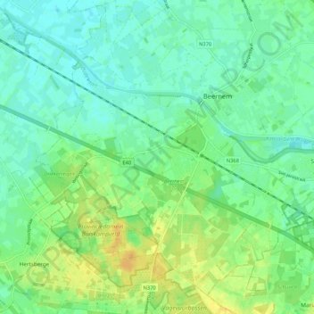
Name: Beernem topographic map, elevation, terrain.
Location: Beernem, Brugge, West-Vlaanderen, Vlaanderen, 8730, België (51.09883 3.27400 51.15674 3.37862)
Average elevation: 39 ft
Minimum elevation: 10 ft
Maximum elevation: 85 ft
Make a donation
Gear up for your next adventure:
As an Amazon Associate, this site earns from qualifying purchases at no extra cost to you.
Other topographic maps
Click on a map to view its topography, its elevation and its terrain.