
Thank you for supporting this site ❤️
Make a donation
Make a donation
Gear up for your next adventure:
As an Amazon Associate, this site earns from qualifying purchases at no extra cost to you.
Ixtapaluca topographic map
Click on the map to display elevation.
Thank you for supporting this site ❤️
Make a donation
Make a donation
Gear up for your next adventure:
As an Amazon Associate, this site earns from qualifying purchases at no extra cost to you.
About this map
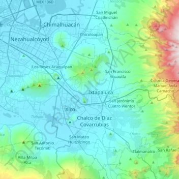
Name: Ixtapaluca topographic map, elevation, terrain.
Location: Ixtapaluca, State of Mexico, 56535, Mexico (19.15293 -99.04405 19.47293 -98.72405)
Average elevation: 8,225 ft
Minimum elevation: 7,297 ft
Maximum elevation: 13,474 ft
Thank you for supporting this site ❤️
Make a donation
Make a donation
Gear up for your next adventure:
As an Amazon Associate, this site earns from qualifying purchases at no extra cost to you.