
Make a donation
Gear up for your next adventure:
As an Amazon Associate, this site earns from qualifying purchases at no extra cost to you.
Saint-Cyr-sur-Mer topographic map
Click on the map to display elevation.
Make a donation
Gear up for your next adventure:
As an Amazon Associate, this site earns from qualifying purchases at no extra cost to you.
About this map
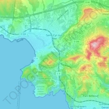
Name: Saint-Cyr-sur-Mer topographic map, elevation, terrain.
Average elevation: 233 ft
Minimum elevation: -3 ft
Maximum elevation: 1,053 ft
Make a donation
Gear up for your next adventure:
As an Amazon Associate, this site earns from qualifying purchases at no extra cost to you.
Other topographic maps
Click on a map to view its topography, its elevation and its terrain.
Plage du Canon
France > Provence-Alpes-Côte d'Azur > Var > Saint-Mandrier-sur-Mer
Average elevation: 59 ft
Berne
France > Provence-Alpes-Côte d'Azur > Var > Saint-Maximin-la-Sainte-Baume
Average elevation: 1,680 ft
Make a donation
Gear up for your next adventure:
As an Amazon Associate, this site earns from qualifying purchases at no extra cost to you.
Puget-sur-Argens
France > Provence-Alpes-Côte d'Azur > Var > Puget-sur-Argens > Puget-sur-Argens
Average elevation: 66 ft
Grotte des Tuves
France > Provence-Alpes-Côte d'Azur > Var > Saint-Cézaire-sur-Siagne
Average elevation: 1,188 ft
La Seyne-sur-Mer
France > Provence-Alpes-Côte d'Azur > Var > La Seyne-sur-Mer > La Seyne-sur-Mer
Average elevation: 115 ft
Make a donation
Gear up for your next adventure:
As an Amazon Associate, this site earns from qualifying purchases at no extra cost to you.
Make a donation
Gear up for your next adventure:
As an Amazon Associate, this site earns from qualifying purchases at no extra cost to you.
Fort du Grand-Saint-Antoine
France > Provence-Alpes-Côte d'Azur > Var > Toulon
Average elevation: 397 ft
Embut de la Plaine des Enfers
France > Provence-Alpes-Côte d'Azur > Var > Cuges-les-Pins
Average elevation: 1,850 ft
Make a donation
Gear up for your next adventure:
As an Amazon Associate, this site earns from qualifying purchases at no extra cost to you.
Make a donation
Gear up for your next adventure:
As an Amazon Associate, this site earns from qualifying purchases at no extra cost to you.