Geolocate

Taquile topographic map

Click on the map to display elevation.

About this map

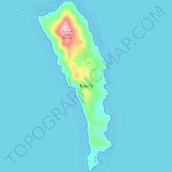
Name: Taquile topographic map, elevation, terrain.

Location: Taquile, Amantaní, Province of Puno, Puno, Peru (-15.79880 -69.69829 -15.74964 -69.67584)

Average elevation: 12,562 ft

Minimum elevation: 12,493 ft

Maximum elevation: 13,356 ft

Gear up for your next adventure:

🥘Titanium Cookware - Durable, featherlight pots and pans for backpacking
🌐World Map Poster - Decorative world maps with topographic info
🎒Day Hiking Backpack - Lightweight backpack perfect for day trips and outdoor adventures
🧭Hiking Compass - Precision compass for reliable navigation in the wilderness
🧤Tactile Hiking Gloves - Keep hands warm while operating GPS and smartphone screens

As an Amazon Associate, this site earns from qualifying purchases at no extra cost to you.