
Thank you for supporting this site ❤️
Make a donation
Make a donation
Gear up for your next adventure:
As an Amazon Associate, this site earns from qualifying purchases at no extra cost to you.
Al Mani` topographic map
Click on the map to display elevation.
Thank you for supporting this site ❤️
Make a donation
Make a donation
Gear up for your next adventure:
As an Amazon Associate, this site earns from qualifying purchases at no extra cost to you.
About this map
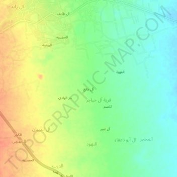
Name: Al Mani` topographic map, elevation, terrain.
Location: Al Mani`, Al `Ali, Sahar district, Sa'dah Governorate, Yemen (16.97800 43.67621 17.01800 43.71621)
Average elevation: 6,263 ft
Minimum elevation: 6,194 ft
Maximum elevation: 6,342 ft
Thank you for supporting this site ❤️
Make a donation
Make a donation
Gear up for your next adventure:
As an Amazon Associate, this site earns from qualifying purchases at no extra cost to you.