Geolocate

Mandapam topographic map

Click on the map to display elevation.

Mandapam

Mandapam is located at 9°17′N 79°07′E / 9.28°N 79.12°E / 9.28; 79.12. It has an average elevation of 9 metres (29 feet).

Wikipedia (CC-BY-SA 3.0)

About this map

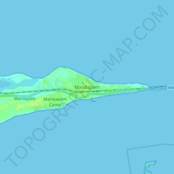
Name: Mandapam topographic map, elevation, terrain.

Location: Mandapam, Ramanathapuram, Tamil Nadu, 623518, India (9.24270 79.11267 9.32270 79.19267)

Average elevation: 3 ft

Minimum elevation: -7 ft

Maximum elevation: 39 ft

Gear up for your next adventure:

🧭Hiking Compass - Precision compass for reliable navigation in the wilderness
🌎3D Topographic Globes - Raised relief globes for a tactile understanding of geography
🧺Microfiber Travel Towels - Compact and fast-drying towels for trail use
👟Trail Running Shoes - Lightweight shoes for trail runners
🧼Biodegradable Camping Soap - Eco‑friendly soap for outdoor hygiene

As an Amazon Associate, this site earns from qualifying purchases at no extra cost to you.