
Thank you for supporting this site ❤️
Make a donation
Make a donation
Gear up for your next adventure:
As an Amazon Associate, this site earns from qualifying purchases at no extra cost to you.
Čačvina topographic map
Click on the map to display elevation.
Thank you for supporting this site ❤️
Make a donation
Make a donation
Gear up for your next adventure:
As an Amazon Associate, this site earns from qualifying purchases at no extra cost to you.
About this map
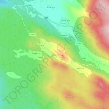
Name: Čačvina topographic map, elevation, terrain.
Location: Čačvina, Grad Trilj, Split-Dalmatia County, Croatia (43.58878 16.77509 43.62878 16.81509)
Average elevation: 1,847 ft
Minimum elevation: 1,299 ft
Maximum elevation: 2,595 ft
Thank you for supporting this site ❤️
Make a donation
Make a donation
Gear up for your next adventure:
As an Amazon Associate, this site earns from qualifying purchases at no extra cost to you.