
Thank you for supporting this site ❤️
Make a donation
Make a donation
Gear up for your next adventure:
As an Amazon Associate, this site earns from qualifying purchases at no extra cost to you.
Frazumeira topographic map
Click on the map to display elevation.
Thank you for supporting this site ❤️
Make a donation
Make a donation
Gear up for your next adventure:
As an Amazon Associate, this site earns from qualifying purchases at no extra cost to you.
About this map
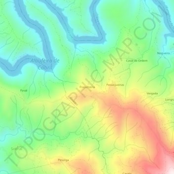
Name: Frazumeira topographic map, elevation, terrain.
Location: Frazumeira, Álvaro, Oleiros, Castelo Branco, Portugal (39.94744 -8.01445 39.98744 -7.97445)
Average elevation: 1,562 ft
Minimum elevation: 866 ft
Maximum elevation: 2,799 ft
Thank you for supporting this site ❤️
Make a donation
Make a donation
Gear up for your next adventure:
As an Amazon Associate, this site earns from qualifying purchases at no extra cost to you.