Geolocate

Mud Lake topographic map

Click on the map to display elevation.

About this map

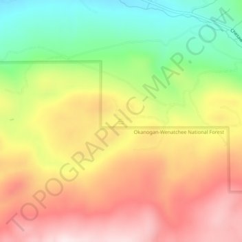
Name: Mud Lake topographic map, elevation, terrain.

Location: Mud Lake, Okanogan County, Washington, United States (48.93093 -119.33932 48.93172 -119.33836)

Average elevation: 2,667 ft

Minimum elevation: 1,847 ft

Maximum elevation: 3,432 ft

Okanogan County trails, hiking, mountain biking, running and outdoor activities

Other topographic maps

Click on a map to view its topography, its elevation and its terrain.

Wauconda

United States > Washington > Okanogan County

Average elevation: 3,881 ft

Havillah

United States > Washington > Okanogan County

Average elevation: 3,665 ft

Mount Barney

United States > Washington > Okanogan County

Average elevation: 6,683 ft

Aeneas Mountain

United States > Washington > Okanogan County

Average elevation: 4,117 ft

Point Defiance

United States > Washington > Okanogan County

Average elevation: 6,033 ft

Baker Mountain

United States > Washington > Okanogan County

Average elevation: 2,959 ft

Mission Peak

United States > Washington > Okanogan County

Average elevation: 4,816 ft

Rock Mountain

United States > Washington > Okanogan County

Average elevation: 7,067 ft

Gear up for your next adventure:

🔥Camping Stove - Portable stove for camping and backcountry cooking
📚Navigation Handbooks - Master the art of reading topographic maps and using a compass
🚗GPS Dash Cams - Record your scenic drives through mountain passes and canyons
👟Men's Trail Runners - Lightweight footwear for fast-paced exploration and light hiking
🔪Outdoor Multitools - Essential survival tools for gear repair and field use

As an Amazon Associate, this site earns from qualifying purchases at no extra cost to you.