
Make a donation
Gear up for your next adventure:
As an Amazon Associate, this site earns from qualifying purchases at no extra cost to you.
Yingjiang County topographic map
Click on the map to display elevation.
Make a donation
Gear up for your next adventure:
As an Amazon Associate, this site earns from qualifying purchases at no extra cost to you.
Yingjiang County
Yingjiang county is mountainous with several alluvial plains. The county has various climate types, with ranges from the tropical, the subtropical, to the temperate zones. Intact forests can be seen in the mountains above 2,000 m (6,600 ft). The elevations vary from 210 to 3,404.6 m (689 to 11,170 ft).
Make a donation
Gear up for your next adventure:
As an Amazon Associate, this site earns from qualifying purchases at no extra cost to you.
About this map
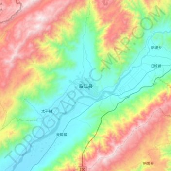
Name: Yingjiang County topographic map, elevation, terrain.
Location: Yingjiang County, Dehong, Yunnan, 665000, China (24.54844 97.77172 24.86844 98.09172)
Average elevation: 4,685 ft
Minimum elevation: 2,605 ft
Maximum elevation: 8,707 ft
Make a donation
Gear up for your next adventure:
As an Amazon Associate, this site earns from qualifying purchases at no extra cost to you.