
Make a donation
Gear up for your next adventure:
As an Amazon Associate, this site earns from qualifying purchases at no extra cost to you.
Merklingen topographic map
Click on the map to display elevation.
Make a donation
Gear up for your next adventure:
As an Amazon Associate, this site earns from qualifying purchases at no extra cost to you.
About this map
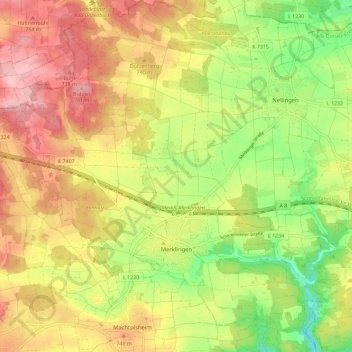
Name: Merklingen topographic map, elevation, terrain.
Average elevation: 2,333 ft
Minimum elevation: 2,060 ft
Maximum elevation: 2,585 ft
Make a donation
Gear up for your next adventure:
As an Amazon Associate, this site earns from qualifying purchases at no extra cost to you.
Other topographic maps
Click on a map to view its topography, its elevation and its terrain.
Berkach
Deutschland > Baden-Württemberg > Alb-Donau-Kreis > Ehingen (Donau)
Average elevation: 1,795 ft
Balzheim
Deutschland > Baden-Württemberg > Alb-Donau-Kreis > Balzheim > Balzheim
Average elevation: 1,798 ft
Rißtissen
Deutschland > Baden-Württemberg > Alb-Donau-Kreis > Ehingen (Donau)
Average elevation: 1,621 ft