Geolocate

Minoh topographic map

Click on the map to display elevation.

About this map

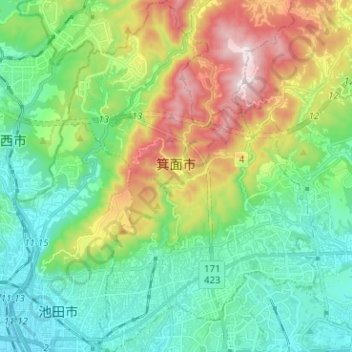
Name: Minoh topographic map, elevation, terrain.

Location: Minoh, Osaka Prefecture, Japan (34.80710 135.43700 34.91087 135.52622)

Average elevation: 709 ft

Minimum elevation: 49 ft

Maximum elevation: 2,188 ft

Other topographic maps

Click on a map to view its topography, its elevation and its terrain.

Nishinari Park

Japan > Osaka Prefecture > Osaka

Average elevation: 13 ft

Gear up for your next adventure:

🩳Quick‑Dry Hiking Shorts - Comfortable and quick‑dry shorts for summer hiking
📶Satellite Messenger - Communication device off‑grid
🧤Hiking Gloves - Protective gloves for rugged trails
👟Men's Trail Runners - Lightweight footwear for fast-paced exploration and light hiking
🧤Tactile Hiking Gloves - Keep hands warm while operating GPS and smartphone screens

As an Amazon Associate, this site earns from qualifying purchases at no extra cost to you.