
Make a donation
Gear up for your next adventure:
As an Amazon Associate, this site earns from qualifying purchases at no extra cost to you.
Zaporizhzhia topographic map
Click on the map to display elevation.
Gear up for your next adventure:
As an Amazon Associate, this site earns from qualifying purchases at no extra cost to you.
Zaporizhzhia
Zaporizhzhia is located in south-eastern Ukraine. The Dnieper splits the city in two; between them is Khortytsia Island. The city covers 334 km2 (129 sq mi) at an elevation of 50 m (160 ft) above sea level. The New and Old Dnieper flow past around Khortytsia: The New Dnieper [uk] is about 800 m (2,600 feet) wide while the Old Dnieper [uk] is about 200 m (660 feet) wide. The island has 12 km × 2 km (7.5 mi × 1.2 mi) sizes. Smaller rivers in the city also enter the Dnieper: Sukha [uk] and Mokra Moskovka [uk], Kushuhum [uk], and Verkhnia Khortytsia [uk].
Make a donation
Gear up for your next adventure:
As an Amazon Associate, this site earns from qualifying purchases at no extra cost to you.
About this map
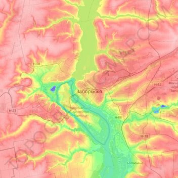
Name: Zaporizhzhia topographic map, elevation, terrain.
Average elevation: 256 ft
Minimum elevation: -141 ft
Maximum elevation: 417 ft
Make a donation
Gear up for your next adventure:
As an Amazon Associate, this site earns from qualifying purchases at no extra cost to you.
Other topographic maps
Click on a map to view its topography, its elevation and its terrain.
Make a donation
Gear up for your next adventure:
As an Amazon Associate, this site earns from qualifying purchases at no extra cost to you.
Make a donation
Gear up for your next adventure:
As an Amazon Associate, this site earns from qualifying purchases at no extra cost to you.
Make a donation
Gear up for your next adventure:
As an Amazon Associate, this site earns from qualifying purchases at no extra cost to you.
Make a donation
Gear up for your next adventure:
As an Amazon Associate, this site earns from qualifying purchases at no extra cost to you.
Make a donation
Gear up for your next adventure:
As an Amazon Associate, this site earns from qualifying purchases at no extra cost to you.
Make a donation
Gear up for your next adventure:
As an Amazon Associate, this site earns from qualifying purchases at no extra cost to you.
Make a donation
Gear up for your next adventure:
As an Amazon Associate, this site earns from qualifying purchases at no extra cost to you.
View on Dnipro Hydroelectric Power Plant
Ukraine > Zaporizhia Oblast > Zaporizhzhia
Average elevation: 148 ft
Zaporizhzhia
Ukraine > Zaporizhia Oblast > Zaporizhzhia
The city is located in south-eastern Ukraine. The Dnieper river splits the city for two parts between them is located the Khortytsia island. The city covers 334 km2 at an elevation of 50 m above sea level.
Average elevation: 272 ft
Make a donation
Gear up for your next adventure:
As an Amazon Associate, this site earns from qualifying purchases at no extra cost to you.