
Make a donation
Gear up for your next adventure:
As an Amazon Associate, this site earns from qualifying purchases at no extra cost to you.
Saal topographic map
Click on the map to display elevation.
Make a donation
Gear up for your next adventure:
As an Amazon Associate, this site earns from qualifying purchases at no extra cost to you.
Saal
2005 beging Saal ihre 750-Jahr-Feier mit einem historischen Umzug und großem Dorffest. Eine Dorfchronik erscheint und erzählt von den Menschen und ihrer Geschichte, die sie erlebten und gestalteten: „Die Gemeinde Saal kann auf eine reiche Geschichte verweisen. Der kleine Ort am Bodden, in Vorpommern gelegen, hatte wirtschaftliche Höhen und Niedergänge erlebt, war beachtet und vergessen. Die Saaler jedoch sind geblieben, was sie immer waren: Ein wenig stur, ein wenig eigensinnig, immer aber liebenswert und bodenständig. Sonst hätten sie vermutlich auch nicht so achtungsvoll den Stürmen der Zeit widerstanden.“
Make a donation
Gear up for your next adventure:
As an Amazon Associate, this site earns from qualifying purchases at no extra cost to you.
About this map
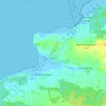
Name: Saal topographic map, elevation, terrain.
Average elevation: 10 ft
Minimum elevation: -13 ft
Maximum elevation: 69 ft
Make a donation
Gear up for your next adventure:
As an Amazon Associate, this site earns from qualifying purchases at no extra cost to you.