Geolocate

Whitney topographic map

Click on the map to display elevation.

About this map

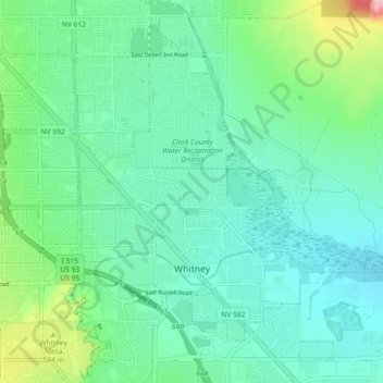
Name: Whitney topographic map, elevation, terrain.

Location: Whitney, Clark County, Nevada, 89112, United States (36.07087 -115.06433 36.13578 -114.97303)

Average elevation: 1,719 ft

Minimum elevation: 1,552 ft

Maximum elevation: 2,320 ft

Clark County trails, hiking, mountain biking, running and outdoor activities

Other topographic maps

Click on a map to view its topography, its elevation and its terrain.

East Las Vegas

United States > Nevada > Clark County > Whitney

Average elevation: 1,680 ft

Gear up for your next adventure:

🥾Men's Hiking Boots - Durable, waterproof footwear for rugged terrain and steep inclines
🎁Geography Themed Gifts - Unique gift ideas for map lovers and geography enthusiasts
🕶️Glacier Sunglasses - Side shields to protect eyes from high-altitude snow glare
😴Insulated Sleeping Pads - Compact and warm pads for high-elevation camping
Camping Coffee Makers - Enjoy premium coffee at the summit or campsite

As an Amazon Associate, this site earns from qualifying purchases at no extra cost to you.