Geolocate

San Ramon topographic map

Click on the map to display elevation.

About this map

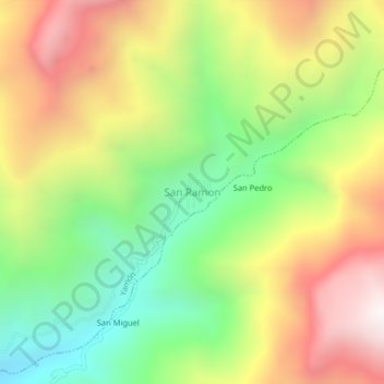
Name: San Ramon topographic map, elevation, terrain.

Location: San Ramon, Yamón, Utcubamba, Amazonas, Perú (-5.99688 -78.47440 -5.95688 -78.43440)

Average elevation: 5,942 ft

Minimum elevation: 3,812 ft

Maximum elevation: 8,442 ft

Gear up for your next adventure:

🕶️GPS Smartphone Mount - Secure mount for phone navigation
📱Solar Portable Charger - Solar power bank for charging devices off‑grid
🛡️Bear Spray Outdoor - Protection in bear country hikes
📚USA Hiking Guide Books - Top trail guides and map books
🪶Trail Camera - Capture wildlife on your hikes

As an Amazon Associate, this site earns from qualifying purchases at no extra cost to you.