Geolocate

Linton topographic map

Click on the map to display elevation.

About this map

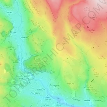
Name: Linton topographic map, elevation, terrain.

Location: Grassington, Linton, Craven, North Yorkshire, England, United Kingdom (54.05957 -2.03103 54.12641 -1.92510)

Average elevation: 1,017 ft

Minimum elevation: 502 ft

Maximum elevation: 1,821 ft

Other topographic maps

Click on a map to view its topography, its elevation and its terrain.

Gear up for your next adventure:

👓Polarized Sunglasses - Outdoor sunglasses for glare reduction
🪶Camping Sleeping Pad - Comfortable sleeping pad for backpacking
🛏️Cold Weather Sleeping Bag - Warm sleeping bag for cold conditions
🩳Quick‑Dry Hiking Shorts - Comfortable and quick‑dry shorts for summer hiking
🗻Climbing Gear Basics - Essential gear for beginner climbers

As an Amazon Associate, this site earns from qualifying purchases at no extra cost to you.