
Pornichet topographic map
Click on the map to display elevation.
Pornichet
The lowest altitude (except shoreline) is of 4 m at the racetrack. The dune behind the beach of the Libraires reaches 9 m. The cliffs of Bonne Source and Sainte-Marguerite can reach 12 m. Going inland, altitudes progressively increase up to 44 m. The highest point is located in the hamlet called Ville ès Blais.
About this map
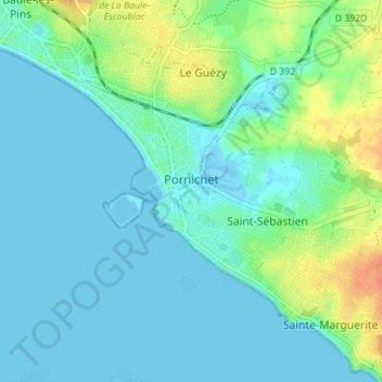
Name: Pornichet topographic map, elevation, terrain.
Average elevation: 30 ft
Minimum elevation: -10 ft
Maximum elevation: 121 ft
Other topographic maps
Click on a map to view its topography, its elevation and its terrain.
La Vieille-Ville
France > Pays de la Loire > Loire-Atlantique > La Chapelle-Glain
Average elevation: 236 ft
La Grande Ragotière
France > Pays de la Loire > Loire-Atlantique > La Regrippière
Average elevation: 262 ft
Réserve naturelle de la Pointe Saint-Gildas
France > Pays de la Loire > Loire-Atlantique > Préfailles
Average elevation: 7 ft
Le Port Cormier
France > Pays de la Loire > Loire-Atlantique > Nort-sur-Erdre > Le Port Cormier
Average elevation: 43 ft
Le Bout des Ponts
France > Pays de la Loire > Loire-Atlantique > Guémené-Penfao
Average elevation: 98 ft