
Thank you for supporting this site ❤️
Make a donation
Make a donation
Gear up for your next adventure:
As an Amazon Associate, this site earns from qualifying purchases at no extra cost to you.
Playa Agua Dulce topographic map
Click on the map to display elevation.
Thank you for supporting this site ❤️
Make a donation
Make a donation
Gear up for your next adventure:
As an Amazon Associate, this site earns from qualifying purchases at no extra cost to you.
About this map
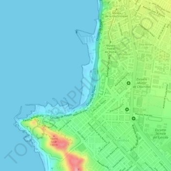
Name: Playa Agua Dulce topographic map, elevation, terrain.
Average elevation: 98 ft
Minimum elevation: -3 ft
Maximum elevation: 394 ft
Thank you for supporting this site ❤️
Make a donation
Make a donation
Gear up for your next adventure:
As an Amazon Associate, this site earns from qualifying purchases at no extra cost to you.
Other topographic maps
Click on a map to view its topography, its elevation and its terrain.
Morro Solar
Perú > Lima > Chorrillos
Por su elevación, los cerros que circundan el Morro Solar son actualmente utilizados para la instalación de antenas retransmisoras de los canales de televisión y de algunas radios de Lima.
Average elevation: 125 ft