
Cânion do Funil topographic map
Click on the map to display elevation.
About this map
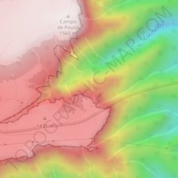
Name: Cânion do Funil topographic map, elevation, terrain.
Average elevation: 3,976 ft
Minimum elevation: 2,070 ft
Maximum elevation: 5,148 ft
Other topographic maps
Click on a map to view its topography, its elevation and its terrain.
Serra do Rio do Rastro
Brasil > Santa Catarina > Lauro Müller
A serra do Rio do Rastro é uma das serras de Santa Catarina, localizada no sul do estado. É cortada pela rodovia SC-390. Com muitas matas e cachoeiras, é um dos cartões-postais do estado. Localiza-se no município de Lauro Müller, a mais de 1421 metros de altitude. Um mirante localizado em seu topo…
Average elevation: 3,530 ft
Rio do Rastro
Brasil > Santa Catarina > Lauro Müller > Bom Jardim da Serra
Average elevation: 4,127 ft