Geolocate

Squire topographic map

Click on the map to display elevation.

About this map

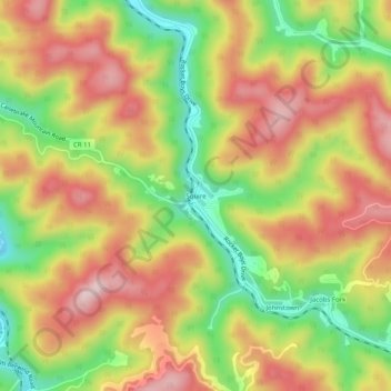
Name: Squire topographic map, elevation, terrain.

Location: Squire, McDowell County, West Virginia, 24884, United States (37.21845 -81.62983 37.25845 -81.58983)

Average elevation: 2,083 ft

Minimum elevation: 1,565 ft

Maximum elevation: 2,539 ft

McDowell County trails, hiking, mountain biking, running and outdoor activities

Other topographic maps

Click on a map to view its topography, its elevation and its terrain.

War

United States > West Virginia > McDowell County

Average elevation: 1,821 ft

Bradshaw

United States > West Virginia > McDowell County

Average elevation: 1,693 ft

Welch

United States > West Virginia > McDowell County

Average elevation: 1,834 ft

Northfork

United States > West Virginia > McDowell County

Average elevation: 2,100 ft

Crumpler

United States > West Virginia > McDowell County > Crumpler

Average elevation: 2,802 ft

Anawalt

United States > West Virginia > McDowell County

Average elevation: 2,110 ft

Bradshaw

United States > West Virginia > McDowell County

Average elevation: 1,693 ft

Gear up for your next adventure:

🧥Men's Rain Shells - Premium waterproof and breathable jackets for mountain weather
💧Water Filtration Bottles - Safely drink from streams and lakes while exploring
🌎3D Topographic Globes - Raised relief globes for a tactile understanding of geography
🥇GPS Hiking Watch - Multi‑sport GPS watch with navigation and trail tracking
GPS Sports Watch - GPS watch for running, hiking and training

As an Amazon Associate, this site earns from qualifying purchases at no extra cost to you.