
Make a donation
Gear up for your next adventure:
As an Amazon Associate, this site earns from qualifying purchases at no extra cost to you.
De Leon Springs topographic map
Click on the map to display elevation.
Make a donation
Gear up for your next adventure:
As an Amazon Associate, this site earns from qualifying purchases at no extra cost to you.
About this map
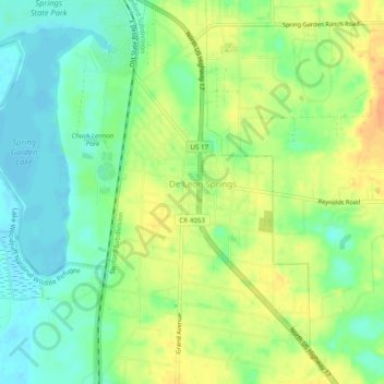
Name: De Leon Springs topographic map, elevation, terrain.
Location: De Leon Springs, Volusia County, Florida, United States (29.09723 -81.36407 29.13965 -81.33587)
Average elevation: 56 ft
Minimum elevation: -3 ft
Maximum elevation: 118 ft
Volusia County trails, hiking, mountain biking, running and outdoor activities
Make a donation
Gear up for your next adventure:
As an Amazon Associate, this site earns from qualifying purchases at no extra cost to you.
Other topographic maps
Click on a map to view its topography, its elevation and its terrain.
Ormond Beach
United States > Florida > Volusia County > Ormond Beach > Ormond Beach
Average elevation: 13 ft
Halifax Estates
United States > Florida > Volusia County > Daytona Beach Shores
Average elevation: 3 ft
Make a donation
Gear up for your next adventure:
As an Amazon Associate, this site earns from qualifying purchases at no extra cost to you.
Make a donation
Gear up for your next adventure:
As an Amazon Associate, this site earns from qualifying purchases at no extra cost to you.
Make a donation
Gear up for your next adventure:
As an Amazon Associate, this site earns from qualifying purchases at no extra cost to you.
Make a donation
Gear up for your next adventure:
As an Amazon Associate, this site earns from qualifying purchases at no extra cost to you.
Wilbur-by-the-Sea
United States > Florida > Volusia County > Wilbur-by-the-Sea
Average elevation: 3 ft
Make a donation
Gear up for your next adventure:
As an Amazon Associate, this site earns from qualifying purchases at no extra cost to you.